Modeling
|
cloud seeding methodsCloud Seeding is used when some natural cloud systems cannot produce precipitation efficiently as they pass over the landscape. Vitally important for increasing precipitation is being able to correctly forecast and identify developing clouds and storms systems with a high potential for producing additional precipitation either by the "static" or the "dynamic" cloud seeding concepts.
|
|
why modeling mattersIt is just as crucial to be able to identify storms with an abundance of supercooled liquid water (SLW) and be able to dispense seeding materials into these clouds at the right time and place within the intended target cloud system(s). Experience and proven seeding technologies are required factors to accomplish this goal, followed by a well organized weather forecast method and operations planning protocol. The development of high resolution modeling systems that can predict SLW with high temporal precision help us reach this goal. RHS Consulting uses HydroWRF, which is a specially adapted automated Quantitative Precipitation Forecasting (QPF) system based on a state-of-the-science mesoscale numerical weather prediction (NWP) system known as the Weather Research and Forecast (WRF) model.
|
Many winter clouds do not contain a sufficient number of natural ice nuclei to produce precipitation efficiently, particularly in the warmer temperatures that supercooled liquid forms.
Static cloud seeding methods introduce additional ice nuclei into clouds to increase the efficiency of the natural precipitation process. New seeded ice crystals grow faster and fallout faster at the expense of competing loud droplets. When ice nucleating agents are released upwind at warmer temperatures on the windward side of a mountain barrier from aircraft they cause the ice process to initiate sooner so that new seeded precipitation to falls out earlier on the windward side of a barrier. The end result is additional precipitation and an increases in runoff in the target area.
Static cloud seeding methods introduce additional ice nuclei into clouds to increase the efficiency of the natural precipitation process. New seeded ice crystals grow faster and fallout faster at the expense of competing loud droplets. When ice nucleating agents are released upwind at warmer temperatures on the windward side of a mountain barrier from aircraft they cause the ice process to initiate sooner so that new seeded precipitation to falls out earlier on the windward side of a barrier. The end result is additional precipitation and an increases in runoff in the target area.
Dynamic seeding involves the release of larger amounts of seeding agents to promote the release of latent heat and increase the buoyancy and volume of a cloud. This type of seeding is usually conducted in convective clouds with higher liquid water contents. In the Sierra these seeding methods are used in late spring and summer events.
Hygroscopic cloud seeding concept is used when clouds contain an overabundance of CCN, cloud condensation nuclei. With too many CCN cloud drop size distributions may not have a sufficient number of large water droplets to initiate the precipitation process. In this situation, hygroscopic cloud seeding enhances the growth rate of large droplets by using complex combinations of hygroscopic salts to stimulate the precipitation process and restore the system to its natural efficiency. Base seeding or just above cloud base is the preferred delivery method used in hygroscopic seeding.
Hygroscopic cloud seeding concept is used when clouds contain an overabundance of CCN, cloud condensation nuclei. With too many CCN cloud drop size distributions may not have a sufficient number of large water droplets to initiate the precipitation process. In this situation, hygroscopic cloud seeding enhances the growth rate of large droplets by using complex combinations of hygroscopic salts to stimulate the precipitation process and restore the system to its natural efficiency. Base seeding or just above cloud base is the preferred delivery method used in hygroscopic seeding.
In the Southern Sierra RHS Consulting combines these methods when seeding late spring convective storms with warm cloud bases. Simultaneous releases of both glaciogenic and hygroscopic seeding aerosols are conducted at cloud base. These storms often develop in monsoonal flows originating from the south that entrain high concentration of CCN. Combination seeding these storms promotes large droplet growth that subsequently freeze and splinter releasing additional latent heat that increases cloud volume and more precipitation.
About hydrowrf
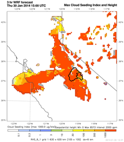
HydroWRF output for Max Cloud Seeding Index on the outer grid.
|
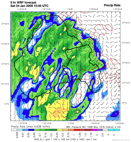
To support RHS Consulting’s cloud seeding programs WRF has been configured to provide optimal forecasts of all standard thermodynamic fields (pressure, wind fields, temperature fields at 32 levels), precipitation rate and accumulation, turbulence, radar echo and cloud coverage while providing explicit calculations of SLW and Ice Crystal Concentrations (ICC). It also produces gridded data that can be automatically imported into local targeting models, used to plot gridded soundings or vertical cross section analyses (RAOB).
HydroWRF produces a 36 hour forecast that is updated every six hours continuously in an operational mode. SLW and ICC totals and maximum with height are computed explicitly. A Cloud Seeding Index (CSI), defined as the dimensionless ratio of SLW/ICC, is also computed and used to provide a graphical picture of the amount of water available to grow natural ice. Systems with high CSI’s are easily identified as good potential seeding candidates. |